Craig y Ddinas Iron Age Hill Fort
Craig y Ddinas Iron Age Hill Fort


Stunning scenery and ancient settlements
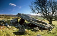
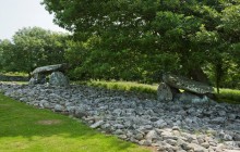
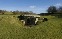
Situated on a lonely, isolated outcrop of rock 350 metres (1200 feet) above sea level, the Iron Age hill fort of Craig y Ddinas boasts dramatic views of the mountains and coastline of the Irish Sea between Harlech and Barmouth. This oval-shaped fort preserves many of its original features, including substantial sections of stone ramparts which, in places, remain standing to near their original height. The elaborate entrance on the eastern side of the defences is cut through by an ancient trackway, which leads to a small plateau with the remains of roundhouses. It is not known whether Craig y Ddinas was a permanent settlement or a place of refuge in times of trouble.
The Craig y Ddinas walk is a linear route of around 4 miles (6 km) that begins and ends at the car park near to Cors y Gedol Hall. It is a walk of moderate difficulty with good tracks. The path leads from the car park up into the multi-period ancient field systems of Cors y Gedol, which feature Neolithic and Romano-British field boundaries and hut settlements, plus the portal dolmen tomb of Cors y Gedol. From here the track gradually climbs the slopes of Moelfre before emerging at Craig y Ddinas to enjoy stunning panoramic views of the surrounding landscape. The views alone are more than enough to justify the effort of getting there!
- Accessible by Public Transport
- Parking
- Good Walks Nearby
- Family Walk
Directions
By Road
Cors y Gedol is off the A496 Harlech to Barmouth road. First left after Dyffryn Ardudwy heading south. Drive up very straight road (Ffordd Gors) to Cors y Gedol - 1 mile.
By Rail
Nearest Station Harlech - 5 1/2 miles. Stop at Dyffryn Ardudwy
By Bus
Nearest bus stop opposite Ffordd Gors
By Bike
On-road cycle route A496
Walking
From Cors y Gedol car park turn right onto Ffordd Ffridd Isaf through gate. Monuments are on the left of the road on the side of the hill.
Access Details
Parking at Cors y Gedol – small charge. Walking boots recommended. Dogs must be on lead.
Practical Details
Full Figure Grid Reference: SH 625230 OS Landranger map sheet: 124
Contact
- Address
- Craig y Ddinas Iron Age Hill Fort, Tal-y-Bont