Tre'r Ceiri
Tre'r Ceiri


Remarkably well-preserved Iron Age hillfort
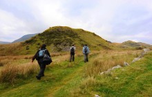
This evocative and breathtaking Iron Age hillfort is one of the best preserved sites of its kind in the country. From its location, 480 metres above sea level on the easternmost summit of Yr Eifl, it would in its time have dominated the area around the Llŷn Peninsula. Excavations carried out throughout the 20th century have provided a wealth of information about this site. Believed to have been constructed in the Iron Age, around 300 BC, the stronghold remained in use well into the 4th century AD and possibly beyond. Finds from the fort are mainly of the Roman period and include pottery, iron tools and spindle whorls.
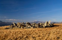
The name Tre’r Ceiri, meaning ‘Town of the Giants’, is well chosen. The main fort is encircled by a formidable single stone rampart, which still stands around 3 metres (10 feet) in height for most of its circuit. Within this rampart were found the remains of some 150 stone huts of varying sizes, some with walls remaining today to a height of 1 metre (3 feet). A far older burial cairn dating to the early Bronze Age, 2000–1500 BC, stands at the summit, and the builders of Tre’r Ceiri have taken care not to disturb this ancient and sacred site during the fort’s construction. The fort has been identified with Caer Dathyl, the chief court of Math fab Mathonwy, whose story forms part of the medieval tale of the Mabinogi.
In 1989 Dwyfor District Council and Gwynedd County Council, with funding from Cadw, began major restoration and preservation work on this fort under the supervision of Gwynedd Archaeological Trust, ensuring its continued survival for many years to come.
Documents
Itinerary Living on the Granite application/pdf / 0.6 MBDownload Audio Tour
Living on Granite - Track 1 - Llithfaen Quarrymen's Memorial audio/mpeg / 1.86 MB Living on Granite - Track 2 - Cae'r Mynydd and the 'Y Wal Fawr' audio/mpeg / 3.82 MB Living on Granite - Track 3 - Tre'r Ceiri audio/mpeg / 2.38 MB Living on Granite - Track 4 - Nant Gwrtheyrn audio/mpeg / 4.92 MBLinks
Archwilio- Accessible by Public Transport
- Good Walks Nearby
- Family Walk
- Viewpoint
Directions
By Road
At Llanaelhaearn take B4419 direction Nefyn. Parking on right after approx. 1 mile.
By Rail
Bangor - 21 miles, Pwllheli - 9 miles
By Bus
Llanaelhaearn bus stop
By Bike
Off-road cycle path alongside A499
Walking
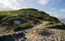
Footpath is signposted 20 yards west of car park
Access Details
Steep mountain path approx. 40 minutes. Walking boots recommended. Dogs must be on lead.
Practical Details
Full Figure Grid Reference: SH 373446 OS Landranger map sheet: 123
Contact
- Address
- Tre'r Ceiri Hillfort, Llanaelhaearn