Caer Seion / Mynydd y Dre
Caer Seion / Mynydd y Dre

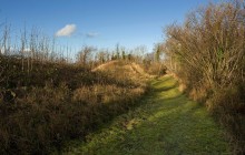
Caer Seion hill fort holds a commanding position overlooking Conwy Bay and the estuary. This large, strong settlement had two periods of defensive activity. In the first phase a single stone wall of 3 to 4 metres width encircled the whole hilltop, apart from at the steep north side where no defence was needed. Most of the wall has now collapsed, but at the north-west side there is a better preserved section. In the second phase a smaller and much stronger fort was constructed at the west end of the original structure.
Excavations were carried out in 1951, but these did not produce any dating evidence. Further excavation in 2008 showed that the fort was occupied from at least the middle of the Iron Age, about 300 BC. No Roman pottery has been found at the fort, indicating that it may have been abandoned when the Romans conquered north Wales in AD 78, although it is possible that it had a medieval use during the time of the princes of Gwynedd.
Within the fort were over 50 roundhouses. Many of them were just behind the rampart at the south side, and they are visible today as circular platforms terraced into the hill's slope. The roundhouses varied in size from about 4m to 8m in diameter internally and traces of walling survive at some of them. The excavations carried out in 1951 found a hearth inside one house within the smaller fort, as well as spindle whorls (for spinning wool) and a quern (for grinding corn).
Links
Archwilio- Accessible by Public Transport
- Parking
- Good Walks Nearby
- Family Walk
Directions
By Road
Follow road over Sychnant Pass, Conwy to Dwygyfylchi.
By Rail
Conwy - 2 miles
By Bus
Mount Pleasant, Llys Sychnant - ¼ mile
Walking
From Synchnant car park aim for summit. Approx 30 minute walk to hillfort.
Access Details
Walking boots recommended. Dogs must be on lead.
Practical Details
Full Figure Grid Reference: SH 760778 OS Landranger map sheet: 115
Contact
- Address
- Caer Seion / Mynydd y Dre, Conwy