Garn Boduan Hillfort
Garn Boduan Hillfort

The legendary home of Buan?
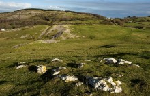
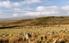
This impressive outcrop of igneous rock rising steeply from the surrounding landscape shows signs of having been occupied on a number of different occasions. The original defences are believed to date to the later Iron Age (about 100 BC), and it was further reinforced in the post-Roman period. Little of the original structure remains today, but extensive excavations carried out in the 1950s identified the remains of around 160 round huts. It is estimated that the original rampart consisted of a rubble-filled dry stone wall up to 6 metres (20 feet) in height. A small fort at the summit of the hill is believed to date to the late Roman or post-Roman period.
Such forts are not unusual at this time,and it has been suggested that Garn Boduan was then reoccupied by a prominent, if not prosperous, local landowner. The name itself suggests an association with the semi-legendary figure of Buan, said to have been a grandson ofLlywarch Hen, the 6th century prince and poet.
Links
Archwilio- Accessible by Public Transport
- Parking
- Good Walks Nearby
- Family Walk
Directions
By Road
Turn off Nefyn to Pwllheli road A497 on to B354 direction Y Ffor. Car parking at Forestry Commission first left.
By Rail
Pwllheli - 4 miles
By Bus
Boduan - ½ mile
By Bike
On road cycling
Walking
Walk up track from Forestry Commission turn in. Keep left up hill and aim for summit.
Access Details
45 minute walk up forestry footpath. Walking Boots recommened. Dogs must be on lead.
Practical Details
Full Figure Grid Reference: SH 310393 OS Landranger map sheet: 123
Contact
- Address
- Garn Boduan Hillfort, Nefyn