Penmon Priory
Penmon Priory

From simple hermitage to princely monastery.
Legend has it that the first Christian to settle at Penmon was a 6th-century hermit called Seiriol. It seems a likely spot for one seeking solitude. Penmon literally means ‘the headland of Anglesey’ (the Welsh name for the island is ‘Môn’) and the remains of the Priory occupy a remote, windy spur of land that juts out into the Irish Sea.
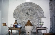
In the Middle Ages Penmon became an important destination for pilgrims. An ancient well, still visible to the north of the church, is named after St Seiriol, and was popular with visitors seeking its healing waters. In 971 Viking raiders attacked the monastic community here, causing much destruction. Two 10th-century stone crosses and a decorated font survived, however, and can be seen in the church today.
Gruffudd ap Cynan paid for the church to be rebuilt in the 12th century, and the tower that you see today, with its striking pyramidal stone roof, dates from this time. Inside the church, look out for the mid-12th-century carving over the arches beneath the tower. It is some of the best work of its kind in Wales.
Under Llywelyn the Great, Penmon became an Augustinian Priory. The large building south of the church was added to house a dining room and dormitory, and enough of this survives to get a vivid idea of what daily life was like for the monks. You can still see the window seat from which a member of the community would have read the Bible aloud as his brethren ate in silence – dining perhaps upon fish from the large pond to the east of the churchyard.
Penmon Priory was broken up when Henry VIII suppressed the monasteries in 1537. At the end of the 16th century the lands came into the hands of the Bulkeley family. They built the remarkable dovecote that stands across the road from the church.
A windy spot on which to explore some fascinating old buildings.
- Parking
- Good Walks Nearby
- Viewpoint
Entry Fees
Free Entry
Directions
By Road
From Beaumaris take the B5109 north for 1.7 miles. Turn right at a T–junction and continue along the lane to the Priory.
By Rail
10.3 miles from Llanfairpwllgwyngyll railway station.
By Bus
No suitable bus service.
By Bike
About 4 miles by quiet roads from Beaumaris.
Walking
The Isle of Anglesey Coastal Path connects Beaumaris and Penmon – it’s about a 4-mile walk.
Practical Details
Full Figure Grid Reference: NGR SH63048072 Coordinates for Garmin satnav users: -4.056608, 53.305754 OS explorer map sheet: 263
Contact
- Address
- Llangoed, Anglesey, LL58 8SP