Torrent Walk
Torrent Walk

This lovely walk follows the ‘torrents’ of the River Clywedog through its striking gorge
This newly completed route, 2½ miles in length, has been designed by the Snowdonia National Park Authority, and you can download information from their website. The walk takes around 1½ to 2 hours to complete. It brings you through woodlands, heading down and then up again, while you marvel at the deep gorge created by Afon Clywedog below.
Head for the wooden signpost nearest the A470. Go through a ‘kissing’ gate and follow the footpath, crossing the bridge over the gorge – look down if you dare! The path then leads downhill, passing a chair dedicated to Mary Richards, a Victorian collector of plants, who lived further upstream at Plas Caerynwch. She travelled a great deal, mostly to Africa, bringing many striking plants back for her gardens.
At one time the banks of the River Clywedog were bursting with industrial activity. There was a fulling mill, smithy, woollen mill and an iron furnace, some of which are still here today. Take a small detour at the Clywedog bridge to see Dolgun Furnace, designed by Abraham Derby. This site, important for its industrial archaeology, also has interesting links to the area’s Quaker history. Nearby Dolgellau became an important Quaker town following a visit by George Fox in 1657.
To complete the walk, cross over Clywedog bridge. Follow the footpath all the way back up to the car park on the B4416.
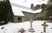
Nearby, just a little way towards the village of Brithdir, is the church of St. Mark’s – one of the finest, and most complete, Arts and Crafts churches in Wales. Built in the 1890s, the church is now redundant and in the care of the Friends of Friendless Churches. It is normally open. In the centre of the village is the site of Brithdir Roman Fort, abandoned in the early 2nd century. Archaeologists found evidence of lead smelting and tanning there.
Links
Torrent Walk Snowdonia National Park Authority- Accessible by Public Transport
- Parking
- Good Walks Nearby
- Family Walk
Directions
By Road
From Dolgellau, follow the A470 to the south. After two miles, turn left for the B4416 towards Brithdir. Cross the narrow bridge, Pont ar Ddibyn, in 50 metres. After a further 100m there is a lay-by on the left with an oak signpost marking the path.
By Rail
Barmouth - 8 miles
Access Details
Rough, steep sections. Wear appropriate footwear.
Practical Details
Full Grid Reference Number: SH 761182 OS Landranger map sheet: 124
Contact
- Address
- Brithdir