Precipice Walk
Precipice Walk

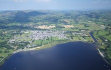
Explore this stunning circular route above the Mawddach Estuary.
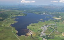
This famous route, barely 3 miles long, manages to pack a wealth of stunning scenery into a short circular walk. Set high above the beautiful Mawddach Estuary, the views to the coast are extensive and breathtaking. To the north lie Snowdon and the Moelwynion, and to the west the remote and rugged Rhinogydd Mountains, with the long escarpment of Cader Idris set immediately south.
The walk itself consists largely of a flat track cut into the steep slopes of the Mawddach Valley. It makes use of an old tramway built to serve the needs of the nearby Voel gold mine. It has been argued that the path follows the course of a Roman leat - a watercourse dug into the ground - but most archaeologists dispute this.
The route follows the level of the 800-feet contour line and involves little by way of climbing or descending. It is ideal as a walk for the whole family, though anyone suffering from vertigo should be cautious at certain points. Having said that, the so-called precipice is by no means as alarming as it sounds, and it offers unbelievable views.
- Parking
- Toilets
Directions
By Road
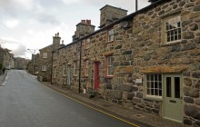
From the centre of Dolgellau, go over the big bridge and turn right towards Bala. After about 500 metres turn left across the road to the library and up a hill towards Llanfachreth. After about 2 miles, at the top of the hill, you will arrive at Saith Groesffordd car park on your left at the junction.
By Rail
Barmouth - 11 miles, Blaenau Ffestiniog - 23 miles
By Bus
Nearest bus stop at Llanfachreth
By Bike
Near NCN Route for Dolgellau
Walking
The whole walk is 3 miles and can be downloaded from the Snowdonia National Park Authority website.
Access Details
Walking boots and map required.
Practical Details
Full Figure Grid Reference - Trail start/end at Saith Groesffordd car park, Llanfachreth: SH 746 212 OS Landranger map sheet: 124
Snowdonia National Park Authority
Contact
- Address
- Precipice Walk, Dolgellau, LL40 2NG