Crawcwellt Iron Age Settlement
Crawcwellt Iron Age Settlement


Bog iron in the Rhinogydd
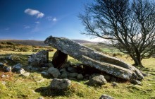
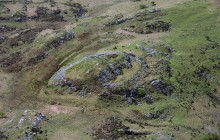
Sheltered beneath the wild and imposing Rhinogydd Mountains, Crawcwellt Iron Age settlement was surveyed and partially excavated between 1986–98 by a team based at Plas Tan y Bwlch. The archaeologists uncovered extensive evidence to suggest that the primary function of this settlement was the smelting and smithing of bog iron.
Bog iron, as the name suggests, is iron produced from ores commonly found in boggy areas. The Crawcwellt settlement consists of the remains of roundhouses, dumps of iron slag and stone-walled enclosures covering an area roughly 200 metres (660 feet) across. A variety of dating methods established that the site had been in use from about 300 BC until the time of the Roman invasion in the mid-1st century AD, when cheaper iron of superior quality became readily available.
Environmental analysis of the area suggests that the surrounding woodlands were originally cleared during the Bronze Age, some 1000 years earlier than the settlement at Crawcwellt was established. Several burnt mounds (possibly cooking places) and a burial cairn were also found. A further clearance is believed to have occurred in the first decade AD involving considerable localised burning. In addition to iron working, a number of subsidiary activities are believed to have been practised here, most notably early farming, including the cultivation of crops. The site has been partially reconstructed for visitors.
Links
Archwilio- Parking
- Good Walks Nearby
Directions
By Road
From Trawsfynydd travel south on A470, take 1st right after Bronaber. Cross over Pont y Grible. Hut circle is approx. 2 miles from junction with main road.
By Rail
Nearest station Porthmadog - 15 miles
By Bus
Nearest bus stop Bronaber - 1.5 miles
By Bike
On-road cycling
Walking
Crawcwellt West and East are near minor road leading to Graigddu Isaf.
Access Details
Easiest to reach is hut circle (SH 688303) just south of road near car park. Walking boots required. For other sites, land is very wet and boggy underfoot. Dogs must be on lead. OS map required.
Practical Details
Full Figure Grid Reference: Hut Circle SH 688303 OS Landranger map sheet: 124
Contact
- Address
- Crawcwellt Iron Age Settlement, Trawsfynydd