Llys Rhosyr
Llys Rhosyr


Unique remains of a royal residence.
During the 12th and 13th centuries, the princes governed Gwynedd in a distinctive way. Their territory was divided into administrative areas called commotes, each of which contained a township known as the maerdref. Each maerdref had a llys – a court or palace, the centre of the royal estate. The princes and their retinue travelled between these llysoedd throughout the year, entertaining allies and dignitaries, dispensing justice and collecting taxes.
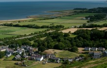
The ruins at Rhosyr in the south-west corner of Anglesey are the rare remains of just such a llys – from the maerdref of Rhosyr, in the commote of Menai. What can be seen today is about one-quarter of the whole site, and it’s really only the stone outlines of buildings that remain. Enough survives, however, to give you a vivid picture of life at the llys.
Within the perimeter wall, the traces of three buildings have been excavated. Most notable are the stone footings of a large hall. This would doubtless have hosted royal audiences and banqueting – the traces of ovens, in which the food for such feasts might have been prepared, have been found nearby. Next to the great hall is a smaller building, thought to have been the prince’s private quarters when in residence. It is worth climbing up the small viewing platform to get a clearer idea of these foundations, and of how extensive the site was in its heyday.
The llys system was abandoned as soon as Edward I conquered Wales. Unlike the castles that the princes built, llysoedd were not made for defence. The complex at Rhosyr has survived so well because it was buried by a severe sandstorm in 1332. It was only uncovered again, and excavated, in 1992.
A place to let your imagination play and get a feel for the princes’ world.
Links
Llys Rhosyr- Parking
- Good Walks Nearby
Entry Fees
Free Entry
Directions
By Road
The site lies west of the village of Newborough, about ½ mile off the A480.
By Rail
4 miles from Bodorgan Station.
By Bus
Buses stop in Newborough. Call Traveline on 0871 200 2233 or go online at http://www.traveline-cymru.info for the latest public transport information.
By Bike
The site lies ½ mile west of the village of Newborough.
Walking
The site lies ½ mile west of the village of Newborough.
Access Details
Easy. Walking boots advised. Dogs allowed.
Practical Details
Full Figure Grid Reference: NGR SH4192865359 Coordinates for Garmin satnav users: -4.366049, 53.161782 OS explorer map sheet: 262
Contact
- Address
- Newborough, LL61 6SG