Bala
Bala

Beautifully situated town, still showing its medieval origins.
The town of Bala stands at the northern end of Llyn Tegid, the largest natural lake in Wales. The Dee Valley stretches to the East, while the River Wnion flows south west toward Dolgellau. The area’s strategic importance from an early time is suggested by the remains of several Roman and medieval fortifications that dot the landscape.
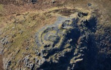
The best preserved of these is Tomen y Bala, a large castle mound, or motte, which stands in the middle of the town. Nine metres high and 40 metres in diameter, this is one of the largest medieval earthworks in Wales. The ditch that once surrounded it has long been filled in and there’s no sign of the bailey – the enclosure that would have stood at the bottom of the mound. The motte itself is well preserved, however, and now forms the centrepiece of a public garden.
Tomen y Bala was probably originally constructed by the Normans, but by the 12th century it seems to have been used as the llys, or royal court, of the princes for the commote of tryweryn. In 1202 Llywelyn the Great took the castle by force from Elis ap Madog, the Lord of Pênllyn, destroying its buildings as part of a campaign to extend his territories in the East. The castle does not seem to have been rebuilt, but in 1310 the English nobleman Roger Mortimer established a borough here.
It is well worth climbing up the steps that have been cut into the mound. From the top you get a clear idea of the layout of this medieval English borough. The long main street has two smaller lanes running parallel to it, and between these you can clearly still see the divisions of the ‘burgage plots’ – the property units that were rented by their occupants.
A wonderful base for exploring the Dee Valley and eastern edge of Gwynedd
- Parking
- Good Walks Nearby
- Toilets
Entry Fees
Free Entry
Directions
By Road
The A494 runs through Bala.
By Rail
15 miles from Betws y Coed railway station.
By Bus
Regular buses serve Bala. Call Traveline on 0871 200 2233 or go online at http://www.traveline-cymru.info for the latest public transport information.
By Bike
The A494 runs through Bala.
Walking
The sites in Bala are easily accessible on foot.
Practical Details
Easy walking. Dogs allowed. Full Figure Grid Reference: NGR SH92803609 Coordinates for Garmin satnav users: 52.909911 ; -3.601584000000003 OS explorer map sheet: OL23
Contact
- Address
- Bala, Betws-y-Coed, Conwy, LL23 7AS